Bridgecourt Watermill
From Wightpedia
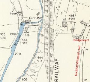
The watermill at Bridgecourt Mill, Godshill, Isle of Wight is shown on a map of 1759 as Bridge Mill but is likely to be the site of an earlier mill.
The mill stands on the eastern River Yar, downstream from the watermill at Ford farm, near Whitwell.
In 1891 the mill was for sale[1]:-
To Millers, Merchants, Speculators, and others.
FRANCIS PITTIS AND SON are instructed by the Trustees of
the will of the late Mr. David Reynolds to Sell by Auction
... the valuable FREEHOLD WATER CORN MILL, situated on the
River Yar, in the Parish of Godshill, three miles from
the Merston station of the Isle of Wight Central Railway,
and five miles from Ventnor and the Undercliff, and known as
"BRIDGECOURT MILL," with dwelling-house, stabling, piggeries,
and other outbuildings, two large gardens, and mill-pond,
the whole containing an area of about two acres.
In 1893 the mill was for sale[2]:-
FOR sale. - The FREEHOLD MILL PROPERTY known as Bridgecourt Mill,
situated in the parish of Godshill, containing three pairs of
stones, new silk flour-dressing machine, and other new and
improved machinery, now let at a rental of £45 per annum.
- Apply to Mr. William Reynolds, Whitwell, Isle of Wight.
situated in the parish of Godshill, containing three pairs of
stones, new silk flour-dressing machine, and other new and
improved machinery, now let at a rental of £45 per annum.
- Apply to Mr. William Reynolds, Whitwell, Isle of Wight.
In the 1898, & 1911 Kelly's Directories, the miller was recorded as Samuel Beeden.
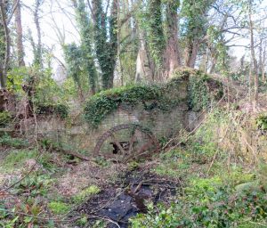
The mill is recorded as being a Corn mill and appears to have ceased operation in the first half of the 20th century and was allowed to fall into dereliction. Today the ruins are on bridleway 21 between Whitwell Road and Bagwich Lane.

